The effects of drought in Kenya have been felt in many ways, ranging from pastoralist-wildlife conflicts, loss of lives, crop failure to water rationing. Kenya’s national
government declared the drought in 23 counties a national disaster on 10th February, 2017. Miles away and the effects have been felt, with Nairobi county rolling out a water rationing programme implemented by the Nairobi Water and Sewerage Company since January, 2017. This comes as the water level in the city’s main source of water, Ndakaini dam, reduced significantly. Ndakaini dam supplies portable water to Nairobi and its environs. The dam has a storage capacity of 70,000,000 m3 at full storage level of 2,041m above sea level, average depth of 65m and a reservoir surface area of 280ha (Report on Thika Dam Background by Howard Humpheys, 2011). The dam Produces 430,000 m3/day of water, which is about 84% of total supply of water to Nairobi residents.
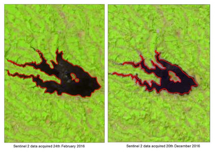
RCMRD sort to assess the impact of the raging drought to Ndakaini dam using space technology. By using Sentinel 2 satellite data, Faith Mitheu and James Mumina analysed two sets of images, February 2016 and December 2016 to assess how the water in the dam has dwindled in the last 12 months. Sentinel 2 images at a resolution of 10m were digitized and a comparison under each area was made. The results show that the reservoir surface area from the February image is 262ha while for December is 169ha. This translates to a reduction in surface area of approximately 93ha, about 35% reduction in the reservoir surface area. This definitely shows that if the drought situation continues, Nairobi county and its environs will continue to suffer a water crisis, and this may trigger other risks such as outbreak of water borne diseases.

Let us try to save and use efficiently the little water we have in our homes and places of work.


