Roysambu, Kasarani
Call: +254 723 786161 / +254 735 981098 | ISO 9001:2015


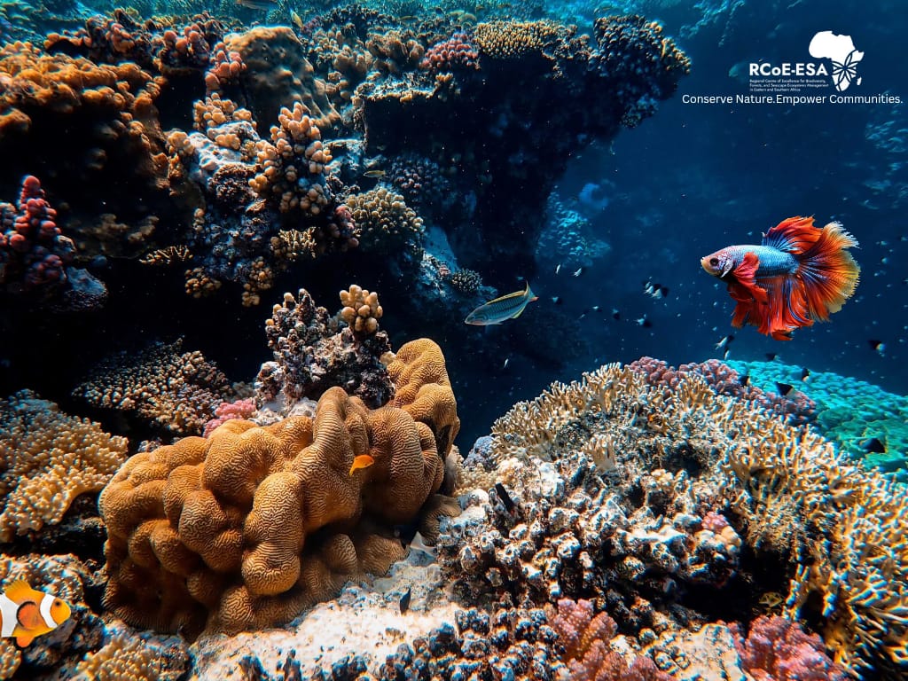
The world’s oceans cover over 70% of the earth’s surface, serving as the planet’s largest habitat, yet only about 1% of these high seas are protected. This leaves the vast majority of marine life in high seas vulnerable to threats such as climate change, overfishing, and increased shipping activity.
The International Union for Conservation of Nature’s (IUCN) Red List of Ecosystems indicates that nearly 10% of marine animals and plants are facing extinction, and at least 41% of threatened marine species are affected by climate. Further, over half of the world’s mangrove ecosystems face collapse, posing a severe threat to coastal biodiversity and livelihoods.
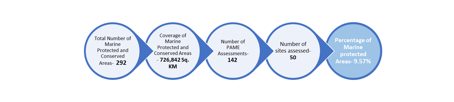
Although it is home to some of the most diverse marine ecosystems in the world, statistics from Protected Planet indicate that only 9.57% of Eastern and Southern Africa's waters are protected. This is significantly below the 30% target set under the Kunming-Montreal Global Biodiversity Framework, underscoring the urgent need for innovative conservation strategies and regional collaboration to bridge the gap.
Countries covered; Angola, Comoros, Djibouti, Eritrea, Kenya, Madagascar, Mauritius, Mozambique, Namibia, Seychelles, Somalia, South Africa, Sudan and Tanzania.
The Great Blue Wall (GBW) initiative is a Western Indian Ocean (WIO)-led, African-driven roadmap to achieve a nature positive world by 2030. It aims to unlock unprecedented nature-based recovery efforts through the establishment of a transformational movement. Its goal is to dramatically accelerate and upscale ocean conservation actions while enhancing socio-ecological resilience and the development of a regenerative blue economy by catalysing political leadership and financial support. The GBW is an action focused and action-driven regional response to 3 interconnected crises, i.e. Biodiversity - Climate – Economy, with three clear objectives to be achieved by 2030. Under the Biodiversity Objective, the GBW aligns with Target 3 of the Montreal-Kunming Global Biodiversity Framework in its ambition to fairly and effectively protect and conserve 2 million km² (30% of the WIO) by 2030 and will advocate and provide support at regional and global levels to achieve complementary results. The GBW data dashboard can be accessed on the RCoE Geoportal (https://rcoe-geoportal.rcmrd.org ).
The Threat of Illegal Fishing and Deep-Sea Mining
Africa loses more than 11 billion usd every year to illegal fishing, with nearly 50% of the industrial illegal fishing vessels operating in African waters. This remains a significant problem, yet only 18 African countries have ratified the WTO Fisheries Subsidies Agreement, indicating laxity in regional enforcement mechanisms.
Additionally, deep-sea mining presents an emerging challenge. Although it offers economic benefits, it poses potential ecological and economic consequences. Alarmedly, no African country has taken an official stance on the issue.
International Agreements, Governance Challenges and Policy Gaps
Weak governance frameworks and policy fragmentation are among the most significant barriers to managing shared marine ecosystems. Countries like Kenya, Madagascar, and South Africa rely heavily on marine biodiversity for their economies, yet inadequate governance structures impede effective conservation efforts.
In June 2023, UN member states adopted the High Seas Treaty which seeks to protect marine biodiversity beyond national jurisdictions, covering over 60% of the ocean. However, participation by African countries remains low, with only Seychelles and Mauritius ratifying the treaty so far. Other African countries need to follow suit in an effort to promote sustainable ocean management within the continent. Similarly, the World Trade Organization (WTO) Fisheries Subsidies Agreement which is designed to combat illegal fishing, has only been ratified by six countries in the Eastern and Southern African region; Botswana, Comoros, Mauritius, Rwanda, Seychelles, and South Africa.
The African Union (AU) is reassessing its Integrated Maritime Strategy (AIMS 2050) to address governance gaps and integrate technological advancements for maritime surveillance.
Leveraging Data and Technology for Effective Marine Conservation
The recent Marine Seascape Ecosystem Management Data & Information Needs Workshop held in Dar es Salaam, Tanzania highlighted the transformative potential of data-driven conservation. The workshop, organized by Regional Centre for Mapping of Resources for Development (RCMRD), emphasized the need for data standardization, transparency, and regional data-sharing agreements. There is need to overcome political barriers to data-sharing to pave way for cross-border conservation efforts. Without collaboration on data governance, piecemeal initiatives will continue to hinder progress.
While some countries, including Kenya and South Africa, have developed marine data platforms, others struggle with fragmented and outdated datasets. The RCoE Data-Geoportal offers a promising step forward. It provides access to conservation data in the Eastern and Southern Africa region with the aim of enhancing ecosystem monitoring and data-driven decision making in ecosystem management.
Technological advancements such as remote sensing, GIS mapping, and drone surveillance have the potential to revolutionize marine ecosystem monitoring. Seychelles and South Africa have successfully been using these tools to track marine biodiversity and detect illegal fishing activities. Thus, expanding access to these technologies across the region, supported by funding partnerships and capacity-building initiatives, could enhance conservation outcomes significantly.
Further, engaging local communities is important for effective marine ecosystem management as they have invaluable indigenous knowledge in relation to understanding biodiversity and ecological patterns.
The Call to Action
The time to act is NOW! Eastern and Southern Africa region must embrace bold and collaborative approaches, harmonize marine conservation policies and integrate indigenous knowledge into sustainable management practices to unlock the full potential of its marine ecosystem.
Among the most critical actions is the adoption of data-driven ecosystem management. Data is increasingly seen as 'the new oil' in conservation, offering immense potential for monitoring and improving the management of the marine environment.
By acting decisively, policymakers, conservationists, and stakeholders can safeguard the region’s marine heritage for future generations, ensuring thriving oceans, resilient coastal economies, and sustainable blue economies across Eastern and Southern Africa.
Author: Abigael Sum

DJIBOUTI CITY’S COASTLINE UNDER PRESSURE: A GROWING CHALLENGE
Djibouti City, the bustling capital of the Republic of Djibouti, sits strategically along the Gulf of Aden, serving as a crucial hub for international trade and maritime activity. However, as the city expands, its coastline is undergoing dramatic changes—some driven by nature, others by human intervention. Rising sea levels, land reclamation, and rapid urban development are reshaping Djibouti’s shores, raising urgent questions about the future of its coastal landscape.
Thanks to satellite data and processing tools from Digital Earth Africa (DE Africa) Sandbox, researchers from the Regional Centre for mapping of Resources for development, (an implementing partner of DE Africa Program) have been able to track the transformation of Djibouti’s shoreline over the past two decades. Datasets derived from Landsat and Sentinel satellites, have provided valuable insights into how erosion and rapid urbanization are affecting the natural environment.
One of the most pressing issues revealed by this analysis is the existence of erosion hotspots. Several parts of the coastline are experiencing rapid shoreline retreat, particularly in areas where major urban and industrial developments have taken place. On the other hand, some sections of the coast are expanding due to extensive land reclamation projects, which have been undertaken to create new housing and port infrastructure. However, these artificial expansions do not necessarily counteract the ongoing erosion in other areas. Meanwhile, climate change has introduced additional concerns - rising sea levels and increasingly frequent extreme weather events are accelerating the rate of erosion, making low-lying coastal areas more vulnerable than ever before.
The rapid growth of Djibouti City has fueled major infrastructure projects, including the expansion of housing infrastructure. While these projects have provided economic opportunities, they have also significantly altered the natural balance of coastal ecosystems. The expansion of the Port of Djibouti, for example, has changed sediment movement and wave patterns, which in turn has contributed to shifts in erosion and deposition along the shoreline.
Additionally, land reclamation projects have played a crucial role in reshaping the coastline. By artificially extending the land through landfill and construction, the natural process of sediment deposition has been disrupted, leading to changes in erosion patterns. At the same time, urban sprawl has increased pressure on the coastal environment. As more buildings and infrastructure are developed along the shore, natural buffers such as mangroves and dunes are being reduced, leaving the coastline more exposed to erosion and extreme weather events.
While human activity has played a significant role in reshaping Djibouti’s coastline, climate change has further compounded these challenges. Rising sea levels pose an increasing threat, as they accelerate erosion and heighten the risk of coastal flooding. The frequency and intensity of storm surges and extreme weather events have also increased, making coastal areas even more vulnerable. Moreover, the degradation of natural coastal barriers such as mangrove forests and coral reefs has further diminished the coastline’s ability to withstand these environmental pressures. Without proper intervention, the continued impact of climate change could lead to severe erosion and even permanent land loss in some areas.
Addressing the challenges facing Djibouti’s coastline requires immediate and proactive measures. One of the most effective strategies is the implementation of nature-based solutions. Restoring mangroves and coral reefs can provide natural buffers against wave action and storm surges, helping to protect vulnerable coastal areas. In addition, sustainable urban planning must be prioritized to ensure that construction in high-risk zones is limited and that climate adaptation measures are integrated into future development plans.
Furthermore, ongoing monitoring is crucial to understanding and mitigating the effects of coastal change. By utilizing satellite data and real-time sensors, authorities can track shoreline movements and make informed decisions regarding coastal management. These efforts will be essential in ensuring that Djibouti’s coastline remains resilient in the face of both human-induced and natural challenges.
The choices made today will determine whether the city’s coastline continues to face instability or becomes a model for sustainable coastal management. By leveraging technology, embracing sustainable urban planning, and investing in nature-based solutions, Djibouti can strike a balance between economic growth and environmental resilience. Protecting the coastline is not just an environmental necessity—it is an investment in the city’s future prosperity. As Djibouti’s urban and economic footprint grows, so too must its commitment to safeguarding its most valuable natural resource—the coast.
Author
Gladys Mwangi-Communications Officer
RCMRD


