GIS and Cartography Section
GIS and Cartography Section aims at providing Geo-information services for sustainable development of the region in line with the theme of Technical Service Department which is “Mainstreaming Geo-information for sustainable development”. Through implementation of projects, a wide user community is reached that cut across policy makers, government ministries/departments and agencies; academic institutions, civil societies, private sector and research bodies. Activities implemented, help transform earth observation technology to policies that transform livelihoods. Products generated are inform of maps, geodatabases, geo-portals, bulletins, atlases and reports. Such products support evidence based decision making related to environmental resource management. Beyond projects, the Section is also engaged in training in applied geo-information services and advisory services to member states. Through capacity building and constant user engagement, GIS and Cartography remains relevant to emerging needs of the society. Main Activities of the Section include:
- Improvement in GIS and geospatial database services through implementation of application projects;
- Spearhead the use and application of GIS technology in various societal benefit areas at global, regional and local levels though training and application development;
- Support member States in the development and implementation of spatial data standards, GIS mapping specifications and its corresponding metadata;
- Provision of advisory services and technical support on the application and use of integrated GIS solutions and geospatial database services to member States;
- Undertake research project on the new tools and open source software for GIS and spatial database development.
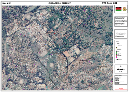
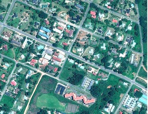
Figure 1: Enumeration area mapping: Population and Housing Census project, Malawi
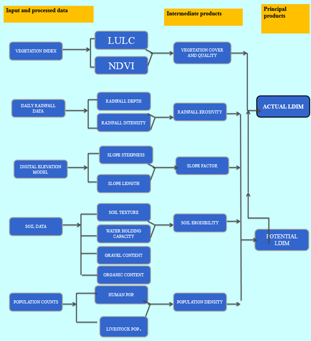
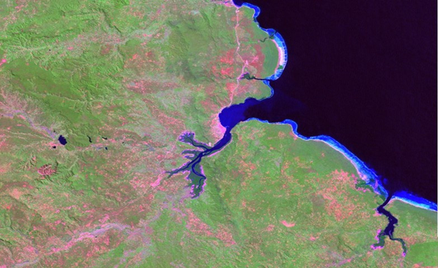
Figure 2: Land degradation Assessment modeling: MESA Project, IGAD
Land Management Section
Close to 80% of any development activity is land related. Information about the location, condition and type of interest different people have over this land is needed for proper planning, sound policy formulation and for timely and equitable services delivery to citizens. However, much of the information is lacking and where available it is in hard copies making processing and analysis difficult. This information should therefore be structured and stored in digital databases and digital maps which are linked together for easier storage, retrieval manipulation and analysis. It is for this reason that RCMRD, under the Land Management section started
- Training course on Land Information System: the objective of training course is to develop capacity in Land Information Management System for its member States and beyond.
- Awareness creation on land administration issues: The Centre conducts awareness activities in our member States that are aimed at sensitizing the decision makers and planners on the need to develop and use land administration systems in all planning and decision making processes
- Projects, Research and consultants in land matters: In collaboration with its partners, RCMRD is involved in the formulation and implementation of various project, research and development focusING mainly on land administration, land governance and land policy
Photogrammetry Unit
Photogrammetry unit is within Remote sensing section.
Photogrammetry remains the most authoritative data acquisition and processing tool for large scale map production. Availability of stereo satellites such as Quick Bird, IKONOS, IRS, World View1, Geoeye1, EROS, ALOS with resolution of up to 30cm for world view3, 50cm for Geoeye1 and 80cm for EROS, make it possible for large areas of the ground to be mapped with reduced ground controls and reduced instrumentation. Again, Photogrammetry being an engineering discipline is heavily influenced by developments in computing and electronics advancement and as such, an update in software calls for a change in procedures through which end products are generated. Owing to the progress made in satellite data acquisition and developments made in the computing arena, RCMRD urges Member States to embrace Photogrammetry techniques and therefore fast-tracking data production for map-updating and NSI development.
Activities:
- Capacity development: Training Member states in the latest technology in the field of photogrammetry. Since inception in 2006, the following member states staff have been trained. Botswana, Burundi, Ethiopia, Kenya, Malawi, Mozambique, Namibia, Rwanda, Somali, Tanzania, Uganda, Zambia and Zimbabwe. Other countries that have had staff trained in Digital Photogrammetry include Angola, Nigeria and Beirut.
- Advisory services: Advisory on new equipment, technology, data sources, (satellites) and methodologies for processing aerial and satellite data, e.g. DEM, Orthophotos. Such advisory are given as presentation to the Country on demand. Only Ethiopia and Lesotho has been offered such services.
- Consultancy services: Assist Member states in project implementation. The services are given to member states on demand. Tanzania, Malawi, Zambia and Mozambique have been offered consultancy services in the AU-Border program.
- Research and Development: Research is done on new application areas in Earth Observation Technology and results presented to members states. Urban mapping using EROS satellite in Ethiopia, Topographic map production using ALOS satellite (Nyeri-Kenya), Large scale mapping using high resolution satellite and Generation of Population Data using high resolution satellite and 3D data capture in Komarock, Nairobi-Kenya).
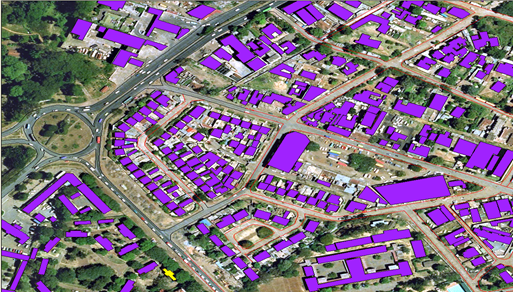
3D data capture – Old Global Round-about

Digital Elevation Model from Wild view-2. Photogrammetry is about precision.
Remote Sensing
The Remote sensing (RS) section falls under the Technical Services Department. The section is headed by the Remote Sensing Officer who is supported by Remote Sensing Technicians and Photogrammetrist. The purpose of RS section is generation, application and dissemination of demand-driven products in RS and provision of effective services in the member states and beyond.
The major activities of the section include:
- Promotion of applications and use of RS in environmental management, disaster management, resource mapping and inventory and urban mapping
- Conduct training and capacity building in the application and use of RS to member states
- Provision of advisory services and technical support on the application of on the application and use of integrated RS solutions to member states
- Carrying out research and application on the use of Earth Observation data in Sustainable Development planning
- Conduct training and capacity building in acquisition, processing and interpretation of aerial photographs to the member states
- Provision of advisory services in the use of photogrammetric systems and migration from analogue to digital systems
- Carrying out research and consultancy services on the application and use of photogrammetric technologies in resource mapping, infrastructure and designing, urban mapping, in precision agriculture and irrigation development.
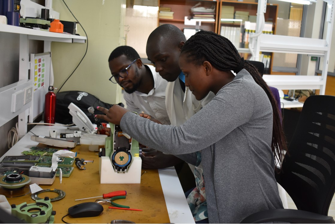
Servicing and Calibration
This section carries out calibration, servicing and repair of member States and private sector surveying and mapping instruments; Some of the equipments are total stations, GPS, theodolites etc

Spatial Data Supply
The Database Management, Archiving and Dissemination Section/ Data Centre is responsible for managing the geospatial database of the Centre that includes acquisition, quality assessment, archiving and dissemination of data to both internal and external clients.
Spatial Data Supply
The RCMRD offers the following satellite imagery data products;
• High Resolution Satellite Imagery - Satellite image data with ground sampling rate below 5 meters (Pixel resolution) i.e. GeoEye, Worldview etc
Image link: https://farm1.static.flickr.com/461/31784963584_83d0c976db_b.jpg

• Medium resolution Satellite Imagery - Satellite image data with ground sampling rate between 5 – 250 meters (Pixel resolution) i.e. SPOT imagery series, Landsat etc.
Image link: https://farm1.static.flickr.com/271/32628396485_0fa2594593_b.jpg
• Low resolution Satellite Imagery - Satellite image data with ground sampling rate above 250 meters (Pixel resolution) i.e. MODIS
Image link: https://farm1.static.flickr.com/313/32628533795_1cedbbc64c_b.jpg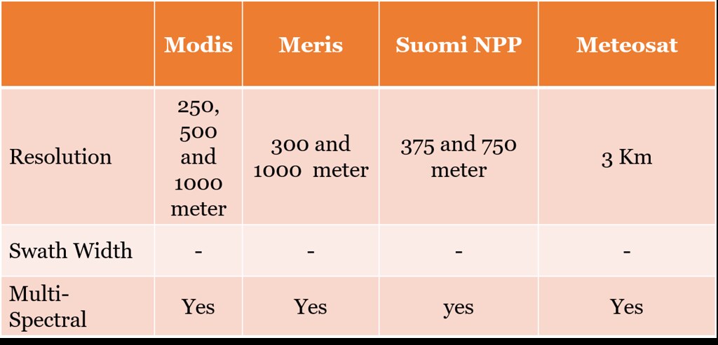
Procedure for Data Acquisition
Clients can make data requests through emails (This email address is being protected from spambots. You need JavaScript enabled to view it.), letters, walk-in, staff outreach, telephone, fax, calls for proposals, advertisements, etc. All inquiries/requests will be received at the Registry Office, registered, and forwarded to the office of the Director General with details including what they need, description (particulars), date, contact details etc.
Useful Link: https://www.arcgis.com/apps/MapJournal/index.html?appid=0a286e23b5234310b281cc60319faf89
Surveying and Mapping
This section offers services that combine professional staff, state of the art equipment and software to ensure that we offer the full suite of Topographical surveying, Engineering surveying, Hydrographic surveying, Cadastral surveying, Control surveying and Training in Land survey related short courses such as GNSS Training, Total station training, leveling among others.
Surveying or land surveying is the technique, profession, and science of determining the terrestrial or three-dimensional position of points and the distances and angles between them. These points are usually on the surface of the Earth, and they are often used to establish maps and boundaries for ownership, locations like building corners or the surface location of subsurface features, or other purposes required by government or civil law, such as property sales. Surveyors use equipment like total stations, robotic total stations, GPS receivers, retroreflectors, 3D scanners, radios, handheld tablets, digital levels, subsurface locators, drones, GIS and other surveying software.
The main disciplines of surveying are:
- Land surveying.
- Engineering surveying.
- Mining surveying.
- Hydrographic surveying.
- Geodetic surveying.
- Photogrammetry and remote sensing.
Land surveying: Land surveying involves measuring and determining property boundaries, which are used as the basis for all property transactions including buying, selling, mortgaging and leasing. Due to the importance of having a secure and strong property market, in Kenya a land surveyor needs to be licensed to be able to carry out a land survey.
Engineering surveying: Engineering surveyors are engaged in the construction industry and ensure construction works are built in the correct location and as per their design. They are generally found on construction sites setting out various types of works such as buildings, roads, bridges, tunnels and various other forms of infrastructure.
Mining surveying: Mining surveyors are involved in the development and construction of mining operations and can generally be found above and underground taking measurements to determine volumes and setting out new excavations and tunneling.
Hydrographic surveying: Hydrographic surveying involves locating and measuring points under the sea and on the shore. There measurements are used to design infrastructure such as docks and jetties as well as ensuring ships have enough clearance from the sea bed to safely travel around the world. Using sonar scanners they are able to provide a picture of the sea bed without needing to get their feet wet and enabling the discovery of ship wrecks and other objects lost at sea.
Geodetic surveying: Geodetic surveyors are involved with undertaking very precise measurements to determine the shape and size of the world and track the movement of continents. Their measurements are used in the monitoring of sea level rise, earthquakes, and the tracking of satellites. Geodetic surveyors are involved in the development of co-ordinate systems and datums which are used in the productions of maps and plans.
Photogrammetry and remote sensing: Photogrammetry and remote sensing involves taking measurements of the world via photography or other wavelength bands such as infra-red or ultra-violet. Measurements may be sources from aerial photography or satellite imagery. Photogrammetry and remote sensing is used to map large areas and determine changes in the world over time.
Application and Dataset
RCMRD offers access to the DATASETS AND MAPS that have been developed and shared online, using platforms such as apps portal, geoportal, open data site that are useful for accessing these spatial based products and services.


